Closer to the Sun: The Dermatological Benefits and Consequences of Living at High Altitude

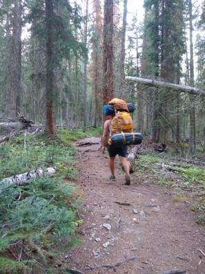
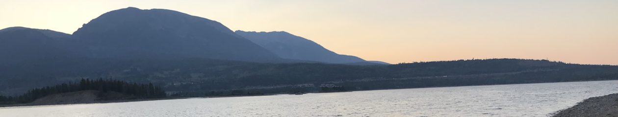
As many of us know, high-altitude living goes hand-in-hand with a multitude of outdoor activities like biking, hiking, and skiing. But with all that outdoor activity comes an insidious risk: radiation from the sun. According to an article interviewing Kim Guthke PA-C, a Physician Assistant working in Dermatology in Boulder, CO, “living at a higher elevation exposes us to approximately 25 percent more ultraviolet radiation when compared to sea level” (Guthke 2018). This means that with all the outdoor activities we enjoy, we must also be proactive about protecting our skin from high altitude sun and the increased risks of long-term skin issues it brings. 

Using thick UV-protectant clothing, sunglasses, and sunscreen (and reapplying it) are great ways to protect our skin from the sun. However, some new research has argued that we are actually hurting our health by staying away from the sun. In a revelational article from Outside magazine called “Is Sunscreen the New Margarine?”, Rowan Jacobsen uncovered a novel study claiming only the sun can provide the vitamin D we need. He claims that we are trying and failing to supply vitamin D with pills alone, and the pills just aren’t good enough. Vitamin D is a vitamin required for calcium absorption whose levels, if low, can increase one’s risk of “cancer, diabetes, obesity, osteoporosis, heart attack, stroke, depression, cognitive impairment, autoimmune conditions, and more” (Jacobsen 2019). Thus healthcare workers have concluded that supplementing it will obviously decrease the risk of these diseases. 

Jacobsen reports that multiple different studies have proven that supplementation of vitamin D just isn’t enough to lower that risk. The studies reported that even if supplementation raised vitamin D levels, the general health of the patient did not improve. There was no correlation between high supplemented vitamin D levels and overall health.

So, why was this?

Jacobson claims that vitamin D is actually just a marker for overall health. In other words, raising vitamin D by artificial supplementation does not make one healthier; rather, to raise one’s vitamin D level one must live a healthy lifestyle outside in the sun. Jacobsen states, “…what made the people with high vitamin D levels so healthy was not the vitamin itself. … Their vitamin D levels were high because they were getting plenty of exposure to the thing that was really responsible for their good health — that big orange ball shining down from above” (Jacobsen 2019). 

Soaking up the Vitamin D on Lake Dillon.

So, what are the implications of this study? Does this mean we all need to stop using sunscreen in order to absorb the most natural form of vitamin D and subsequently decrease our risk of dangerous diseases? Well, yes and no.

Yes, in that the best way to absorb vitamin D is from the sun and sunscreen does inhibit that absorption.

No, in that one day of playing at the beach and getting horribly sunburnt is not going to raise your vitamin D levels enough to benefit your health.

Unfortunately, the answer is quite complicated. I believe the implication of this new information is that we all need to start getting outside every day, exercising, enjoying the mountain air, and absorbing small amounts of sunlight each day, rather than just enjoying a single session of baking our skin to blisters. Living at high-altitude, I hypothesize that we don’t need as much time to absorb the same amount of beneficial sunlight as we would at sea level, so I feel there is still a need for sunscreen and protective clothing, if outside for an extended period. We should all try to absorb the sun’s rays daily, but we need to do it in a healthy way.

Cooling down on the way up Uneva Peak off Vail pass.

I encourage everyone to read Jacobson’s article, as it has points both for and against protection from the UV rays of the sun. In the meantime, there is one point Jacobson makes that I would like to argue. 

In his article, Jacobsen admits that increasing sun exposure does increase the rate of skin cancer, but then claims this is ‘okay’ because, “Skin cancer kills surprisingly few people: less than 3 per 100,000 in the U.S. each year … People don’t realize this because several different diseases are lumped together under the term ‘skin cancer.’ The most common by far are basal-cell carcinomas (BCCs) and squamous-cell carcinomas (SCCs), which are almost never fatal” (Jacobsen 2019). The reason I’m disagreeing with this point is due to my direct experience with the “non-fatal” skin cancers. I spent 12 months working with a board-certified dermatological surgeon performing Mohs micrographic surgery, a delicate and precise surgical procedure to remove said cancers from the face, ears, scalp, fingers and toes. Although it’s true BCCs and SCCs are rarely fatal, they can cause significant damage to one’s image. Depending on the location and size of the cancer, a “non-fatal” SCC in-situ has the potential to cause extensive disfigurement of the face, ears, or eyes. I strongly believe this is not something to take lightly, and I fear that saying skin cancer is non-fatal creates a false sense of security. This can be especially dangerous in high-altitude where the sun’s rays are exceptionally stronger than the majority of the US. 

All in all, I do believe that the sun is incredibly beneficial to our health, though in moderate portions. Living in the Colorado mountains gives us more opportunities to enjoy the mountain air, along with the sun, and allows us to lead healthier lives in general. I don’t think I’m going to stop using sunscreen in the near future, but I do know I won’t be so afraid of the sun anymore. I definitely won’t be letting the sun keep me from enjoying my time here in Colorado!

Delaney Schara is a Physician Assistant student at Des Moines University in Des Moines, Iowa. She hails from Fergus Falls, Minnesota, and obtained her undergraduate degree in Chemistry at Augustana University in Sioux Falls, South Dakota. Delaney gained valuable experience in medicine by working as a medical scribe in Dermatology prior to beginning PA school. After completing her pediatrics rotation with Dr. Chris, Delaney will have rotations in multiple Midwestern states before her graduation in June 2020. Delaney is an avid musician who loves singing in choir, playing the flute, and playing acoustic guitar. She also enjoys tasting new blends of tea, exploring rural communities, and spending time with loved ones. 

References

Guthke, Kim. “Sun Protection at Higher Altitudes.” Boulder Medical Center, 29 August 

2018, www.bouldermedicalcenter.com/sun-protection-at-higher-altitudes/

Jacobsen, Rowan. “Is Sunscreen the New Margarine.” Outside Online, 6 June 2019

www.outsideonline.com/2380751/sunscreen-sun-exposure-skin-cancer-science?utm_source=pocket&utm_medium=email&utm_campaign=pockethits

Wilderness Medicine & Medicine for our Wilderness

Our mission of advocacy and community building continues at our little mountain clinic as the aspen leaves have just begun to turn, and our passion for high altitude research has brought us to a unique and timely junction between the Wilderness Medicine Society‘s conference in Crested Butte, Colorado that Dr. Chris attended, and a recent conversation with the founder of The Sustainable Hiker, Summit County resident and voice of the Wilderness, Tom Koehler.

As health care providers in the high country, we see patients experiencing all kinds of reactions to the extreme altitude, residents and visitors alike. Even those who aren’t out climbing fourteeners or skiing can often experience symptoms of acute mountain sickness. Needless to say, we also see our share of injuries in the more adventurous outdoor-inclined. We ourselves make a point of regularly venturing out into the celebrated Colorado forests to experience this demanding environment first-hand, and it is not always without incident, in spite of our expertise and careful planning, and these past Spring and Summer seasons have been no exception, between hut trips, fourteeners, camping, kayaking, stand up paddle-boarding, cycling, lifting, yoga, and running at 9000′ and above! It is our due diligence and life’s work to share our experiences and the valuable research being done across the globe with you.

Dr. Chris and her contemporaries have returned from the Wilderness Medicine conference this year with some good and bad news. First, the good news:

Dr. Chris receives some impromptu wilderness medicine for a scrape on a recent trip to Harry Gates hut.
  1. There are no brown recluse spiders in Colorado, according to Kennon Heard, MD (although Dr. Chris’s sister-in-law disagreed with this expert’s statement).
  2. Most snake bites do not inject venom, so anti-venom treatment is only indicated if symptoms are noted. The anti-venom is very expensive, but treatment of the wound is important in order to control the cascade of events set off by the venom, starting with a diffuse reaction similar to a severe anaphylaxis, followed by neurotoxic fasciculations of muscles, along with a necrotizing wound causing pain and swelling at the site of the bite and ending in a full disruption of every clotting factor and cell in the body. The clotting disruption does not lead to hemorrhage. In layman’s terms, most snake bites aren’t shown to lead to symptoms, but should you experience any symptoms, things could escalate to life-and-death very quickly.
  3. Another useful talk was given by a specialist in foot care, Patrick Burns, MD, DiMM (Diploma in Mountain Medicine): He recommends wearing two pairs of acrylic socks and protecting areas of friction with paper tape. He rejected the ointments and gels as unproven. Don’t use duct tape, as it damages the skin, and moleskin tends to be too thick. Blisters should be left intact, although consider draining if pain is intense. Healing takes 120 hours.
  4. For accidents and injuries, studies show that irrigating wounds with water is as good as saline, and a well-filled Camel-bak makes an excellent splint for fractures. Pain was addressed by Alex Kranc, MD, FAWN (Fellow Academy of Wilderness Medicine): doses of acetaminophen 1000 mg and ibuprofen 400 mg or Naprosyn given together or alternately are as good as stronger prescription medicines in most cases. A system of acupuncture without needles that is light and compact has been shown to help with pain in combat situations (where, incidentally, many of these techniques and tools are developed). Think of a sticky patch that you apply to a pressure point behind your ears.
  5. Linda Keyes, MD discussed women at altitude, including some helpful tips for dealing with menstruation on wilderness treks: menstrual cups catch the flow and can be washed and used over again; taking the active birth control pills continuously will delay the onset of bleeding. Another piece of good news: bears (and sharks) are not attracted by menstrual blood.
  6. In a discussion about training for altitude events, Aaron Campbell, MD, MHS, DiMM, FAWM reviewed the role of sleeping in hyperbaric chambers or tents, which showed a mild improvement in adaptation. The best way to prepare for climbing Mt. Kilimanjaro, he said, is to climb a fourteener every week for 6 weeks!
A slide on improvising a Camel-bak bladder as a splint at the 2019 Wilderness Medicine conference in Crested Butte, Colorado.

The most exciting and spellbinding parts of the conference, according to Dr. Chris, were the descriptions of rescues from mountains, crevices, and ledges from Alaska to Boulder.

Now for the bad news:

Michael Loso, PhD gave a fascinating talk on the science of glaciology and water acquisition research in Alaska. Poo on the glacier gets buried and frozen, and lasts for years, if not decades, and they have even found traces of E. coli around certain base camps too high for drinking standards. This obviously can significantly compromise water quality, even at higher elevations, where we imagine the water from snowmelt is of the most pristine quality, a subject I also speculated about with Tom Koehler. This is why you should carry a proven filtration system. Tom’s preference, when possible, is an 8-minute boil.

Can you see the Rocky Mountain big horn sheep?

But what about the Wilderness itself? Colorado’s Continental Divide plays a major role in where our water goes, how it gets there, and in what condition. Sixty-eight percent of Colorado’s forests are federally owned and protected, one of the highest in the nation. With the continuing rise in residence and tourism, increased traffic through our precious forests is a double-edged sword.

“Summit County is really a microcosm, but an example of a larger issue facing Colorado: exponential growth, both in permanent population, as well as increase in guests to our land. So that, on a high level, has water managers scratching their heads, wondering, ‘How are we going to deliver the water we need for businesses and human health?’,” explains Koehler. “Summit is unique, particularly in the water issue, because we supply a significant amount of runoff into the Colorado River at the headwaters in Kremmling. And that arguably touches an estimated 40 million people all the way to California,” giving a rough estimate.

“A lot of Colorado is struggling to maintain their trails. We have about 430 miles of trails of all uses. In this county, we have a lot of trails to maintain, and arguably, that’s our first line of defense against erosion into our streams. It’s just a cascading effect (pardon the pun),” he says. “Most every park and forest in the West is under strain for maintenance. We just happen to be the most recreated, visited in the country, with 4.4 million recreational visits per year.”

Koehler’s passion for conservation and preservation of our forests and watershed was fostered in natural forests of Shenandoah Park, where he frequently escaped to while working as a research director for a wealth management firm in Washington, DC, while also dreaming of a career as a competitive skier in Park City, Utah.

“Once the opportunity arose to head out West with a couple of pennies in my pocket, I took it, and my move to Summit County was transformational in that I saw nature first-hand, right outside my door.” It transformed his outlook on how it benefits us all, even economically. He started volunteering with the Summit Huts Association, which provided him with “tremendous opportunity to really be in the backcountry”, the High Country Conservation Center, where he “really carved out an ethos for [himself] of stewardship”, and was even named the Friends of the Dillon Ranger District Volunteer Recruiter of the Year for 2015.

The Sustainable Hiker was founded as a response to recognizing that the efforts on a lot of fronts being made by organizations wasn’t as widely broadcast to both locals and guests. It’s mission: to be the leading voice for protecting Nature.

“I see the Sustainable Hiker as part of a number of organizations from the stewardship to the climate change advocacy groups to the local conservation groups, where you can find out what’s going on with your land and water here in Summit County.

“A healthier forest provides me with cleaner air and cleaner, more reliable water. It’s taken for granted. Kind of like a factory that turns out profits, it has to be maintained to continue yielding as high a profit.” Spoken like a true financier.

Setting off through the Eagle’s Nest Wilderness below Buffalo Mountain in Summit County, Colorado.

So what is one thing Colorado residents can do, immediately, to forward this movement of sustainability?

“Immediately, wherever you reside or are visiting, look at a nature or forest stewardship project, or educational events related to our forest or nature, and sign up.”

What is one thing we can stop doing that will contribute to the preservation and conservation of our forests and water?

“Stop, right now, taking nature for granted. Because we need it.

“Stop relying on your car for everything.

“Stop talking. In Nature … our time in Nature is a time to slow down everything, including our conversations. For two reasons: for the joy and peace we experience listening to the birds, and it gives the wildlife a break, too.”

Below treeline on the way up to Harvard and Columbia peaks outside of Buena Vista, Colorado.

I understand his point. While living in Japan, I learned a word, “shin-rin-yoku” (森林浴), literally translating to “forest bath”. The idea revolving around the practice is that by walking through the trees and water in the forest, you exchange ions with it, providing your body with a balancing recalibration. I believe this is also a vital part of high-altitude health.

The Sustainable Hiker provides insight into Koehler’s mission, at sustainablehiker.com, where you will also find information on organizations, events, and his newsletter, Nature’s Beacon, drawing attention to conservation projects you can get involved in.

robert-ebert-santos

Roberto Santos is from the remote island of Saipan, in the Commonwealth of the Northern Mariana Islands. He has since lived in Japan and the Hawaiian Islands, and has made Colorado his current home, where he is a web developer, musician, avid outdoorsman and prolific reader. When he is not developing applications and graphics, you can find him performing with the Denver Philharmonic Orchestra, snowboarding Vail or Keystone, soaking in hot springs, or reading non-fiction at a brewery.

Mt. Shavano & Tabeguache Peak

This past weekend, we ended Dr. Chris’s birthday week celebration with an ascent up Mt. Shavano, at 14,229′ (4337 m). We didn’t make it to the summit of the neighboring Tabeguache Peak, but I’m including it in the title of this piece because it was very much a part of our experience on this particular trek.

The standard summer route up Shavano and Tabeguache starts at 9700′, outside of the town of Salida. Up to the summit of Shavano, there is a 4400′ elevation gain over about 4.2 miles. If this is hard for you to imagine, know that it is formidable. Additionally, the trail increases in difficulty the further you progress, and the last .6 mile to the top is one of the most challenging ascents I’ve ever done without a heavy pack. In a previous article, I mentioned anticipating an inner dialogue about turning around before summiting. This inner dialogue didn’t involve me turning around so much as just passing out on a rock and staying there forever. But I did manage to summit after a 5.5 hr ascent, which included a 2-mile detour past and then back to the very first sign indicating the trail, in the dark of the early morning, at the very beginning of the hike. As obvious as the sign should have been, I’m relieved to say we weren’t the only ones.

This is the wooden sign indicating the Colorado Trail and the trail to reach Mt. Shavano and Tabeguache Peak.
The sign, .1 mi from the trailhead, that we somehow missed in the dark of the early morning.

And this is precisely why you should bring several resources to help guide you. In spite of all the trail descriptions with mileage that we brought, the only sure indication we had passed the turn-off from the Colorado Trail were the actual GPS coordinates of the sign listed in one of our resources (14ers.com). Pro tip: you can enter GPS coordinates into your Google Maps app (assuming you have service); leaving off the capital letters for cardinal directions (N, S, E, W), the first number will be latitude, the second longitude (in our case, we entered “38.60218, -106.19594” to find the sign we had initially passed).

Another learning experience on this particular trek was regarding our camp site. We had chosen the Angel of Shavano camp site, close to the trailhead, which is outside the town of Maysville, past Salida (about two hours from Frisco). The site is right at the foot of the mountains in that area, quite small (20 spots, first-come-first-serve, $20 per night for two vehicles). I was expecting a lot of other hikers, going to bed earlier than us, to wake up and start their ascent earlier than us, with more expensive, specialized gear, but was surprised to find all our neighbors partying until hours after we had retired into our tents.

Icing these puppies in a beautiful river along the Angel of Shavano campground.

As it turns out, there is a Winter route up Shavano, and the trailhead for the standard Summer route was about a 30-minute drive back toward Salida from the Angel of Shavano campground. So that explains why we didn’t encounter any other early-risers there. The good news is that Angel of Shavano campground is gorgeous, right off the Colorado Trail, along a beautiful river that, this late in the summer, was flowing shallow and slow enough that I could set a chair in it and soak my feet in the icy water (before putting them through hell the next day).

A half-moon over Angel of Shavano campground.

We ended up at the trailhead for the Summer route the next morning at 5:15 am. Pitch black. Here’s another pro tip: if your headlamp is dim, it needs new batteries.

Be aware that this parking lot is referred to as the “Blanks Trailhead Parking Lot” on signs on the trail, and this sign is the only one that reads “Mount Shavano Tabeguache Peak Trailhead”.

Other than missing what would have been a very obvious sign in the daylight, the rest of the trail was pretty much straight up. Even the switchbacks were steep enough to make me think, “Would it be much steeper if we just went straight up?” If you’ve ever climbed Peak One in the Ten Mile Range above Frisco, it’s like that (or any portion of that) times a hundred.

The dawn breaking as we backtrack toward the sign we missed.

It’s also significant to note that this was the second time in my life I’d ever wished for hiking poles. The steep grade had me pushing off my own thighs constantly as I trudged up the incline, and my quads were burning the entire hour-and-a-half it took me to get back down. Yes: 5.5 hours up, 1.5 hours down.

The water in my Camel-bak was all I’d brought on the trail (after drinking from a couple Nalgene bottles I’d brought in the car), and I ran out just before getting back to the trailhead. One of us ran out of water in her Camel-bak on her way up to the summit. Fortunately, another one of us had packed an extra gallon of water.

As far as snacking went, we had plenty of jerky, pistachios, bananas, nut butter, and electrolytes between us. I may even have had a chocolate-covered Twinkie. But we didn’t finish all of that, and as I’d expected, my body didn’t really crave food so much as liquids, until I’d reached the end of the hike, at which point I promptly finished all traces of food in the car.

Dr. Chris taking a break on the saddle below the summit of Shavano.

All-in-all, I’d say that was a successful excursion, and even the mistakes we made affirmed that even experienced hikers should take extra care. My main takeaway: don’t rush the start of the trail. It is worth hours to be sure where you are headed, even if it means standing in one spot, double-checking all your resources, entering GPS coordinates for 20 minutes.

The treacherous terrain up the last .6 mi to the summit of Mt. Shavano.

Also notable: we started back on the right track toward the beginning of the hike just before 7 am, at which point it was already bright out, and I reached the summit at 11 am. By 11:15, all the distant clouds had amassed into huge thunderheads, and the first rumble of thunder had us packing up pretty quickly. And this isn’t the first time I’ve seen this. No matter how far away you think those clouds are, it takes mere minutes for them to travel. And as white and interspersed as clouds may seem, they can collect into large, grey, stormy masses very quickly. So, beer in hand, I started a quick descent from the peak. I’d already run for my life down a fourteener in a lightning storm once, and I don’t ever plan to do that again. Furthermore, the summit area of Mt. Shavano is little more than a huge pile of rough boulders, a type of terrain requiring your hands as well as your feet to navigate, called talus. The trail is neither clear nor safe, and there is no way you are running down it.

Do you see a trail here?
Neither did we.

Finally, the weather was the main reason we didn’t make it to the neighboring Tabeguache Peak. A local we talked to on the trail who had made the ascent numerous times advised us to budget at least an hour each way to and from Tabeguache. It’s only about a mile away, but it’s a rocky, narrow ridge. And sure enough, on our way down, it started hailing along with the thunder (and in my experience with fourteeners this time of year, it always does), rained lightly twice through the forest, and then poured torrential rain toward the bottom of the trail.

Would I recommend this trek? Definitely. It is a true test of fitness, and even more so, stamina. As with any other trek, and as I always strongly advise, be wise and pre-emptive about how far and how fast you go. Elevations above 8,000′ are when your body’s reaction to the altitude become exponentially more dramatic, so you can bet elevations above 10,000′ put you at much higher risk for all kinds of symptoms of altitude illness. The faster you ascend, the greater the risk. And remember, our party set out well before daylight at 5:30 am. In the future, should I plan to summit both of these beasts, I would certainly start no later than 4 am.

Other than that, do your homework and prepare accordingly, and you’ll be in for the time of your fitness-challenging, self-motivated lives! Happy Trails!

Beer and jerky time, 5.5 hours later, atop Mt. Shavano at 14,229′.
robert-ebert-santos
Roberto Santos on an epic powder day at the opening of The Beavers lift at Arapahoe Basin ski area.

Roberto Santos is from the remote island of Saipan, in the Commonwealth of the Northern Mariana Islands. He has since lived in Japan and the Hawaiian Islands, and has made Colorado his current home, where he is a web developer, musician, avid outdoorsman and prolific reader. When he is not developing applications and graphics, you can find him performing with the Denver Philharmonic Orchestra, snowboarding Vail or Keystone, soaking in hot springs, or reading non-fiction at a brewery.

Climbing a Fourteener: An Insider’s Abridged Guide

Some of your friends have done one or two and a couple are on their way to having ascended their 20-something-eth peak over 14,000 ft. You’ve heard the views are breathtaking, the sense of accomplishment is riveting, and it makes you that much more secure in calling yourself a Coloradan.

Climbing fourteeners has become a popular quest for so many residents and visitors to Colorado, and as I prepare to take on another one myself, I thought I’d share my process of preparation for anyone looking for insight. There are a lot of very practical guides out there, everything from maps to trail descriptions. Hopefully, what I have to tell you is some less-than-obvious, experience-driven advice.

Every fourteener is different. Elevation in itself is a poor indicator of the level of difficulty of any trail. Mt. Evans, at 14,265 ft. (4348 m.), has a paved road all the way up to the top. Mt. Princeton at 14,196 ft. (4327 m.) took me several hours to hike and I was on all-fours to climb any set of stairs the next few days.

Oops …..

Access is everything. I mentioned there are ample resources out there, including regularly updated printed literature as well as online accounts. Take it from me: read them all. Many of these peaks have several approaches, and trails sometimes intersect. The difference may be hours! Some friends and I set out to climb Mt. Harvard (14,423 ft., 4396 m.), in the Collegiate Peaks outside Buena Vista. When we got to the top (after a few hours of hiking), the small cardboard sign tucked under some rocks read “Mt. Columbia 14,078′” (4291 m.)”. Imagine our surprise.

You can’t always rely on your phone, either, so take maps, print out trail descriptions (including any of trails you don’t plan to take), and check them often during your ascent.

Timing. Timing, timing, timing, timing, timing. You may have heard this already, and any Coloradan will tell you that no matter how clear, sunny and calm the first part of the day is, the weather can change in an instant. Even if it remains calm at the base of a 14er, these high peaks will rake in the clouds. Shortly after we summited Mt. Columbia (as in, within five minutes), we noticed some grey clouds in the distance. Then we started to hear the crackling of static all around us. Then lightning. Then we proceeded to run all the way down that rocky mountain questioning every decision we’d ever made. During the 30 or 40 minutes of very dangerous running and leaping back down to the tree-line (an ascent that took us hours), all I could think was, “So this is how it ends. My family won’t even find out for days.” Luckily we made it down, and my companions couldn’t tell I was crying because we were soaking wet from rain and hail.

Start early. Before dawn if possible. I’m not exaggerating.

Anticipate every climate. There is often still snow on Colorado’s highest peaks, even at the height of summer heat. You will be sweating all the way up, but as soon as you stop to rest, the biting wind toward the summit will prompt you to unpack every layer you shoved into your tiny Camel-bak.

Pay attention to distance and elevation gain. Ascending 2000 ft. in 8 miles is a vastly different experience than ascending 2000 ft. in 4 miles. If you can’t imagine what either of these feels like, definitely try some lower summits before attempting a 14er. Peak One, just over Frisco, in the Ten Mile Range summits at 12,933 ft. (3942 m.), but the elevation gain is almost 4000 ft. in less than 5 miles. I’ve done this hike several times, and I always, always find myself debating whether it is totally necessary that I reach the top.

This weekend, I’ll be headed up Mt. Shavano at 14,299 ft. (4337 m.), outside of Salida. It’s a 4600-ft. gain over almost 5 miles, so this tells me I’ll be having that inner dialogue about turning back early at least a couple times on my way to the summit. It’s been 95 degrees (F) at 7000 ft. during the day recently, so that tells me I’ll be in all my layers, including a hooded jacket when we set out on the trailhead before daylight, I’ll strip all the way down to shorts when the sun rises after an hour or two, then put it all back on when we reach the top.

One piece of advice on water and snacks: lots of water, lots of snacks. I very personally prefer to give my body some extra calories the night before we set out on the trail, and I don’t expect to consume a lot of weight on my way up. However, as soon as I’ve reached the top and all I have to worry about is the (often less-intensive) descent, my muscles start craving nutrition and hydration.

Remember, turning around is always an option. If someone in your party is struggling or the weather looks like it will be taking a turn for the worse, don’t wait until it’s too late to head back to safety. These mountains aren’t going anywhere fast. Other than the above-mentioned, maybe lesser-known details, don’t forget the usual: sun protection, sturdy and comfortable shoes, some basic first aid, and a plan to maintain communication with those in your party.

If you’ve had any close calls hiking fourteeners in Colorado or any additional wisdom you’d like to pass on, please do share them in the comments! In the meantime, stay tuned for a follow up on our Mt. Shavano ascent, and Happy Trails!

robert-ebert-santos
Roberto Santos on an epic powder day at the opening of The Beavers lift at Arapahoe Basin ski area.

Roberto Santos is from the remote island of Saipan, in the Commonwealth of the Northern Mariana Islands. He has since lived in Japan and the Hawaiian Islands, and has made Colorado his current home, where he is a web developer, musician, avid outdoorsman and prolific reader. When he is not developing applications and graphics, you can find him performing with the Denver Philharmonic Orchestra, snowboarding Vail or Keystone, soaking in hot springs, or reading non-fiction at a brewery.